


Latest News
Acadian Archives Exhibit of Ancient Maps of the New World
September 16, 2016
Note: this is an archived news release. As such, the information provided may no longer apply.
NR16049
The Acadian Archives/Archives acadiennes, of the University of Maine at Fort Kent, is currently exhibiting a large number of historical maps from the private collection of Jacques LaPointe. LaPointe is a Franciscan priest, author, historian, collector, and world traveler.
The thirty-nine maps on display range widely in geography and in time. The earliest maps circa 1522-1532 are depictions of “Discovering America” according to seven cartographers of different European countries. The most recent maps reveal the United States’ claim to the “highlands” of Témiscouata and Britain’s claim to the “highlands” of Mars Hill, Maine before a compromise led to the Treaty of Webster-Ashburton of August 9, 1842 and the adoption of the St. John River as the international boundary between New Brunswick and Maine.
Lise Pelletier, curator and director of Acadian Archives/Archives acadiennes explains, "These maps span more than 300 (1522 to 1842) years of discovery of the New World. It is fascinating to see how quickly the maps evolved to reflect newly found rivers, lakes, lands, and First Nations. We also get a glimpse of the different imperialistic interests of France, Spain, England, Germany, and Holland in this new territory. Each map is a work of art with detailed cartouches, hand-colored scenes and is rife with information. The Archives is truly honored to display such a wonderful collection."
Father LaPointe noted, "Maps about Acadia and the Atlantic Coast are increasingly sought after in the field of Acadian studies. I am delighted to be among the new researchers-geographers of colonial and modern Acadie. My particular interest also reflects the new concept of Acadia of the Lands and Forests, one of the border areas most mapped in America!"
LaPointe was born in Van Buren, Maine and grew up in St. Leonard, New Brunswick, in the historic “Grande-Rivière Settlement.” He graduated from the University of Moncton with a B.A. in political science and an M.A. in Acadian Studies. LaPointe later earned a certificate in “Cultural Development” in France.
Jacque LaPointe has worked with several international development agencies and has lived in North America, Latin America, Europe, and Africa. Since his ordination in 1997, he has served the ministry in Quebec and New Brunswick, in Asia, Australia, and in Europe. Until a few years ago, he was a parish priest in the St. John Valley. Currently, he is a minister at St. Anthony Shrine and Ministry Center in Boston.
Father Jacques has published several books, short stories, and articles on Acadian history. He recently published “Of Stars & Steeples,” history of the parishes in the St. John Valley; and “Les enfants du Ciel” (The Children of Heaven) about his spiritual encounter with a terminally ill child.
Listed here are a few maps included in the exhibit:
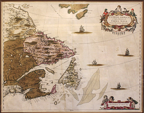
“Extreme Americae Versus Boream, ubi Terra Nova Nova Francia” by Johannes Blaeu (1596-1673) is based on Champlain’s 1632 map of Acadie, along with other maps from the Dutch East India Co, and from fellow cartographers De laet and Jansson. This map is a superb example of Blaeu’s work, famous for its attention to detain in both cartographic accuracy and baroque decoration. The elaborate title cartouches symbolize the importance of the Grand Banks fisheries. This map is not only a certified Blaeu map but also a rare collectors’ item.
“Carte de la Nouvelle-France” by Sr Samuel de Champlain, carries the inscription: “Sr Champlain from 1603 to 1629 has discovered many coasts, lands, lakes, rivers, and Nations, and the settlements made by the French.”
Michael/Gerardus Mercator (1512-1594) author of “America sive India Nova ad magnae” created the system of projection now named after him, in which lines of longitude, as well as latitude appear as straight, parallel lines.
The 1657 North America map (authorized reproduction) by Nicolas Sanson will influence North American cartography for the next 100 years. Alexis Hubert-Jaillot (1632-1712) is another important French cartographer of the 17th Century.
The exhibit consists of six very large maps and sketches of Fort Louisbourg from a book “Louisbourg – From its foundation to its fall 1713-1758” by J. S. McLennan, 1918. They are very valued by modern military strategists, as important historical war treasures. Louisbourg, located on l’Acadie’s Cap Breton Island, was the seat of French power on the coast of the North Atlantic. The American militias from Massachusetts, Connecticut, and other parts of the American Colonies played an important part in the 1745 capture of the Louisbourg fortress. Some inhabitants of Louisbourg ended up in Acadia of the Lands and Forests (Grande Rivière: Van Buren and St. Leonard) in 1789.
In addition to these beautiful and highly interesting maps, Father LaPointe’s collection includes a hand-colored star chart by John Flamsteed (Paris 1795) depicting Virgo and neighboring constellations, from Fortin’s Atlas Celeste de Flamsteed, and a print of a wood engraving published in Harper’s Weekly in 1858 called “Lumbering in Maine and New Brunswick – Drawing the Logs to the Creek.”
This exhibit will be on display until January 2017. The Acadian Archives/Archives acadiennes is open weekly, every day, from 8 am to 4:30 pm. For more information, you may call the Archives at 834-8631 or visit our website at: www.umfk.edu/archives/